Vigilyst.comDeutschOpen situation room

Live situation room

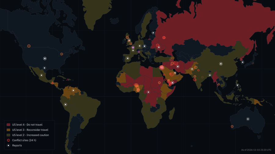
The world situation on one map: travel warnings and risk per country, conflict sites, situation reports, military flights and sea lanes, with a 14-day look-back. Free, no sign-up.

25countries at the highest warning level
14 dayslook-back
24/7live, free
Vigilyst situation room: world map with US travel advisory levels per country, conflict sites and current reportsOpen situation room

What you can discover

The situation room shows what matters right now and what has changed since yesterday. Countries are coloured by the travel warnings of Germany, the US or the UK, or by the Vigilyst risk index; changes since yesterday are numbered on the map.

On top come situation reports from the media and authorities, conflict sites, military aircraft and naval vessels with anomalies such as clusters or special flights, sea lanes and chokepoints, airspace restrictions, natural hazards and cyber attacks. Click a dot for the details, click a country to open its dossier with travel advice, reports and cameras.

The timeline below the map lets you rewind and replay the situation of the last 14 days.

Countries with the highest warning level

US 4 = US travel advisory level 4 (“Do not travel”), DE = German Foreign Office travel warning. Click to open the country dossier in the situation room.

Frequently asked questions

What does the situation room show?

The current world situation on one map: travel warnings and risk per country, situation reports, conflict sites, military anomalies, sea lanes, airspace restrictions, natural hazards and cyber attacks.

Can I see what the situation was a few days ago?

Yes. The timeline below the map lets you rewind and replay the situation of the last 14 days.

Does the situation room cost anything?

No, it is free to use without an account.

More on Vigilyst

Live cameras worldwideMore than 126,000 public live cameras from 67 countries on a 3D globe: traffic cams, webcams, weather and volcano cams plus live streams.Live flight trackerLive flight tracker with about 13,000 aircraft worldwide right now, including military and emergency squawks, on a 3D globe.Live ship trackerTrack ships worldwide live: cargo ships, tankers, ferries and cruise ships on a 3D globe, plus ports and chokepoints.Live satellite trackerThe ISS, space stations, GPS, Galileo and weather satellites live on their orbits around a 3D globe, plus the ISS live stream and rocket launches.Earthquakes & natural events liveLatest earthquakes worldwide, volcanic eruptions, wildfires and storms live on a 3D globe, plus volcano live cams.Live traffic camerasTens of thousands of live traffic cameras: highway webcams, mountain passes, bridges and junctions in the US, Canada, Japan, Europe and more.Live weather webcamsSee the weather instead of reading about it: weather cams, mountain and panorama webcams, road-weather cams and buoy cams worldwide, plus cloud map and rain radar on the 3D globe.Volcanoes liveVolcano live cams from Kīlauea (Hawaii), Etna (Sicily), Iceland and more, plus current eruptions and earthquakes worldwide live on the 3D globe.Where is the ISS right now?Track the International Space Station live: the ISS's current position and orbit on the 3D globe, plus the live stream looking down at Earth and other space stations.Aircraft emergencies – squawk 7700 liveWhich aircraft are declaring an emergency right now.Aurora forecastNorthern lights tonight.Rocket launches liveThe next rocket launches worldwide with countdown, launch site on the 3D globe and live stream – SpaceX, NASA, ESA, Rocket Lab and more.Space weather & solar stormsSolar storm now: Kp index, NOAA scales for radio, radiation and geomagnetic storms, forecast and alerts live in the situation room – plus the aurora forecast on the 3D globe.Ports & chokepoints liveShip traffic at the chokepoints of world trade live: Suez Canal, Strait of Hormuz, Bosporus, Panama Canal, Strait of Malacca and the major world ports on the 3D globe.Live rain radarRain radar worldwide on a 3D globe: current precipitation, showers and storms, plus cloud map and webcams to see the weather on the ground directly.Live cloud & satellite mapCurrent cloud image of the whole Earth from satellite data on a rotating 3D globe, with day-night terminator, rain radar and live webcams.Live news mapLatest reports from major outlets – disasters, accidents, protests, emergency operations – placed on a world map, with nearby cameras.Free OSINT toolOSINT in the browser: public cameras, ADS-B flight data, AIS ship data, satellites, earthquakes and news on one globe – for research, verification and situational awareness.The Earth live on a 3D globeThe Earth in real time: interactive 3D globe with live webcams, aircraft, ships, satellites, cloud map, day-night terminator and earthquakes – free in your browser.

The world situation at a glance.

Conflicts, travel warnings and reports – clearly laid out on one map.

Open situation room